The national park named after the glacier is equally oversized, the largest in all of Europe. It is not only the jumping off point for excursions up on to the glacier, it is also home to Iceland's largest forest but of course, this island is not a place of forests.
We would not be going up on to the ice cap itself on this trip to Iceland. Perhaps next time. But we would be hiking up some 800 meters through the light forest and alpine meadows to gain a view of a massive glacial tongue, overlooking a broad glacial plain
The trail wound up through meadows and brush (an Icelandic notion of a forest differs greatly from a Canadian's I'll tell you that much) where Collette found these pretty little flowers, common to the south of Iceland
On our way up we passed by, guess what .. a waterfall. Everywhere you go in Iceland you pass by a waterfall. This one poured down over cliffs of basalt that time and the glacier had formed into impressive geometric patterns
We continued up, leaving the forest behind, giving way to glacier-carved vallies where giant moraines of rubble dotted the horizon
As we climbed the air became clearer, a bit thinner, it was another beautiful sunny day and we began to see the tongues of the great glacier dominating the skyline
Anna brought us to a place where we were surrounded by the glacier and far below us was vast plain with perfect circular lakes and long sinuous rivers created by the passage of the glacier thousands of years before
At the visitor centre of the national park we learned about the negative side of this incredible and beautiful natural wonder, that severe flooding from the glacier created a disaster that took many lives and changed the face of Iceland forever, diverting rivers and causing bridges to be rebuilt
Iceland is a remarkable country where its unique and powerful geography is both blessing and curse. This is a tough country; without real forests, early settlers relied upon driftwood from Siberia to build their boats and houses. Fish is abundant here but it was settlers from other regions who had to bring in boats big enough for true commercial fishing. There are many rivers rich with salmon but those rivers try to kill you. The volcanic soil is equally rich but those volcanoes regularly try to kill you.
We drove south through Eldhraun where two lava fields combine to create a space of about 560 square kilometers. This lava resulted from a year long eruption that was one of the most poisonous in history; about 80% of the animal population and over 20% of the human population was killed
But Iceland overall is not a bleak and lunar landscape. It is this country of clamorous waterfalls and rich green vallies where it's volcanic heretidge can suddenly appear in the most surprising and spectacular way
A beautiful landscaped occasionally used photo staging areas by ernest yet goofy tourists
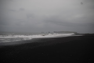
We drove south, along the coast and as we did in the west, ran into more typical Icelandic coastal weather. The rain was coming in sheets off the Atlantic and it gave an eerie feeling to stone spires that we could see in the distance as we entered the area of Vik, the wool capital of Iceland
Vik is the southernmost village in Iceland and is known for its long black sand beach, caves that were once used by pirates, and cliffs that host nesting puffins, birds that generally spend most of their lives at sea
And of course, in southern Iceland, Collette and I managed to find a border collie. OK, he wasn't a collie but he was a herding dog from a nearby sheep farm who came down to the beach to mug for the tourists and to herd the ATVs
The rainy cool weather followed us as we made our way to Seljalandsfoss, a large waterfall that you could actually walk behind
It was a crazy kind of day. We started off climbing through alpine pastures to look at a glacier. In the sunshine. We ended by walking a black sand beach and strolling behind a waterfall. In the rain.
That's Iceland. Here's the video


No comments:
Post a Comment